 Charles Alexandre Lesueur, Public domain
Long before GPS, satellites, or compasses, Indigenous cultures across the world were navigating vast landscapes and open oceans with remarkable accuracy. From Polynesian voyagers who crossed thousands of miles of open sea to Aboriginal Australians navigating the outback without maps, these navigation systems didn’t rely on modern tools—they relied on deep cultural knowledge, observation, and memory. Today, scientists and historians are still trying to fully understand how these methods worked with such precision.
Polynesian wayfinding used the stars, waves, and birds.
Perhaps the most widely studied example of Indigenous navigation is Polynesian wayfinding. These oceanic explorers travelled from island to island across the Pacific, navigating thousands of miles in double-hulled canoes without maps or compasses. They used stars as directional markers, memorising their rise and set points on the horizon. But it didn’t stop there.
They also read the ocean swells, recognising how different patterns of waves interacted, bounced off islands, and moved through the archipelagos. Clouds were clues too, especially the way they formed over islands or reflected light. The presence of certain birds, like frigatebirds and terns, signalled nearby land. These techniques were passed down orally through generations of master navigators, or “wayfinders,” and are still taught today by some Polynesian communities. Modern oceanographers have confirmed the astonishing accuracy of these methods, even without instruments.
Aboriginal Australians used songlines to cross the continent.
Aboriginal Australians developed a system known as songlines—routes across the land encoded in song, story, and ceremony. These were more than just paths; they were complex oral maps. Each verse of a song represented a specific feature of the land, like a hill, a rock formation, or a watering hole. By singing the songs in sequence, travellers could navigate huge distances with astonishing precision.
Songlines weren’t just personal or local knowledge. They stretched across the entire continent, linking communities and serving as trade and communication routes. The same songline could be known to different groups in different languages, but still describe the same path. Scientists studying these practices have found they often align closely with known topographical features and ancient trade routes, revealing an intricate and still underappreciated understanding of geography and memory.
Inuit navigators used snowdrift patterns and subtle landmarks.
In the vast, often featureless Arctic, Inuit people developed highly specialised navigation techniques based on their intimate knowledge of snow, ice, and sky. One of their most unique tools was the reading of snowdrift shapes, known as sastrugi. These wind-carved patterns on the snow indicate direction because they form consistently in response to prevailing winds.
Inuit travellers also memorised specific arrangements of distant mountains, coastlines, or ice formations—landmarks that might look invisible to outsiders but formed a mental map. In addition to visual cues, they paid attention to the feel of the wind, the sound of sled runners on different snow textures, and the migration patterns of animals. Modern researchers, including anthropologists and climatologists, have studied how Inuit knowledge allows for real-time adaptation in extreme conditions where GPS would often fail.
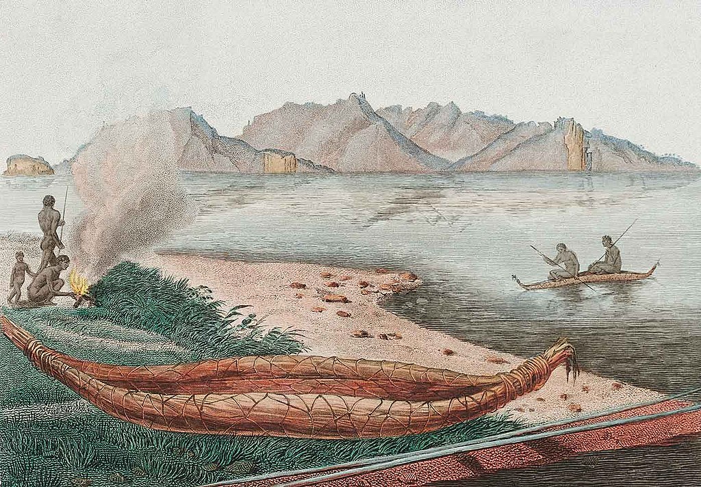
Micronesian stick charts represented wave patterns.
On islands like the Marshall Islands, navigators used stick charts, which were intricate hand-crafted tools made of coconut fronds and shells. These weren’t maps in the way we think of them, but abstract representations of ocean swell patterns and the positions of islands. The curved sticks indicated the paths of waves as they interacted with land, while shells marked island locations.
Each chart was unique to the navigator who made it, and they were rarely taken on journeys. Instead, they were used as memory tools before a voyage. Navigators would study them and internalise the patterns. Scientists have marvelled at the complex understanding of wave dynamics these charts represent. Knowledge that Western science didn’t fully map until much later.
Amazonian tribes navigated the forest using sound and scent.
In dense rainforests where visibility is poor and paths can quickly become overgrown, some Amazonian tribes developed navigational techniques based on sound, scent, and minute environmental details. They learned to identify locations by the calls of birds, the buzzing of insects, or the smell of specific plants and trees. Footpaths were often indistinguishable to outsiders but encoded with subtle signs, such as broken twigs, scraped bark, or disturbed leaves.
This hyper-awareness allowed them to move fluidly through thick jungle environments where modern tools would be useless. Their ability to navigate without getting lost has been documented by researchers working alongside Indigenous guides, who can often retrace routes even after decades. These methods demonstrate an immersive, sensory connection to the landscape.
Sámi reindeer herders tracked landscapes through seasonal memory.
In the Arctic regions of Scandinavia, the Sámi people relied on oral memory and generational knowledge to track the movement of reindeer herds across thousands of kilometres. Instead of fixed maps, their navigation was seasonal and dynamic, based on the behaviour of animals, the growth patterns of vegetation, and the condition of snow or ice.
Routes were remembered in layers, with older generations teaching younger ones how to read the land not just as it was, but as it would become. This meant knowing when rivers would freeze or thaw, when valleys would flood, and when certain berries or moss would grow. Even now, many Sámi herders continue to use this ancestral knowledge, sometimes alongside snowmobiles and GPS, to manage reindeer migrations.
Native American tribes used horizon markers and celestial calendars.
Various Native American cultures incorporated astronomy into their navigation and timing systems. In the American Southwest, the Pueblo people aligned structures with solstice sunrises and used distant landmarks as horizon markers to guide movement and ritual. These horizon-based systems allowed for accurate orientation in open desert landscapes.
Some tribes built stone cairns or placed poles that would cast shadows at particular times of year, acting as natural calendars and navigational aids. Combined with their knowledge of seasonal plant cycles and animal migrations, this allowed for detailed planning of travel and trade. Archaeologists continue to uncover alignments and settlement patterns that suggest a sophisticated use of natural cues.
Across the world, Indigenous navigation methods reveal a profound relationship with the environment.
These systems were not just about finding a way from one place to another. They were cultural, spiritual, and deeply tied to survival. Modern researchers continue to learn from them, not just because they are clever, but because they offer an entirely different way of understanding movement, memory, and space. In many cases, the accuracy and complexity of these techniques still baffle scientists, and continue to inspire new ways of thinking about navigation today.